The grand master scheme is to ride the Arizona Trail, Mexico to Utah. The culmination will be the big ride sometime in Spring 2005. But it begins now. Today we explored endless singletrack north of the town of Oracle.
We jumped out of the pickup on Tiger Mine Rd around 8am. A huge “ARIZONA TRAIL” gate stands on the side of a ridge. The trail goes under the sign, and from our vantage point, off into space. The wind was howling and storm clouds sat parked on the Catalina Mountains, ready to fire at us. It looked like the beginning of an epic ride.
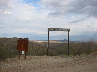
Arizona trail gate on Tiger Mine RD.
We fussed over what clothing to bring, and I immediately wished we were thru-riding (with all these decisions behind us). Shane flip-flopped about twenty times as to which jacket he would bring. But eventually we rode through the AZT gate, off into space. Clouds, switchbacks, gusting winds, and big smiles followed.
I had ridden this section to Tucson Wash before, but only once. It’s a difficult trail to ride (other than out-and-back), so it doesn’t get much use. We would soon find out just how difficult it is to put together a ride on this trail.
We dropped into and out of the six washes along the trail. It seemed like we were descending more than we were climbing, but our friendly tail wind was deceiving us. Before we knew it we emerged on the gas line, fresh and ready for more adventure.
After some fine granny gear grunts, gaining elevation, we crested out to a fantastic view. To the south was the Catalinas, still holding the storm clouds at bay. Southwest we could see the blinking tower visible on the other side of the 24 hour course. To the west, the red slopes of Antelope Peak, shooting out of a sloping desert basin. The gas line seemed to stretch on forever. With this rate of climb/descend into drainages it looked to be a long ride.
The ups and downs rescinded, however, and the tail wind blasted us down the gentle slope at 15-20 mph. If I were hiking this section I’d be killing for a mountain bike. We listened to our tires roll, swishing through the smooth sand, surfing contours to dodge occasional rocks. It was so quiet, yet so fast. I was keenly aware of my surroundings, following the line that my tires led to. Flow.
At Camp Grant wash we started an uphill run on the gas line. Some steepness was present in the climbs–enough to present challenge, but not enough to force dismounts.
We crested one of many hills when Shane announced his tire needed to be changed. He had already been pumping up his front, but now his rear had a slow leak as well. Lee and I helped him rip his bike apart, change and patch tubes, then get back on the road. As you might guess, this was not to be our last flat from Mr. Peltonen.
We climbed onto the giant shoulder of the sloping valley, then started a short descent to Bloodsucker Wash. The AZT carsonite post was knocked over in the sand. An unclear Private Property sign was ahead of us on the gasline, but I knew it was time to hit the wash. We started cranking our speed up to carry through some of the deep sections of this “road.” For the most part, it was not bad. Slow, but not bad. Certain times of the year this might be a mess on a bike, and going up it would surely be a walk. But things could be worse, and it’s a beautiful little canyon. I couldn’t look around much, as most of my mental energy was directed towards finding the most solid line, but I did stop for some pictures and to rest my upper body.
We found some silver hangers on the brush right where my GPS directed us. Some rough trail followed, but I managed to clean the entire climb out of the wash–even one switchback that I thought was impossible. At the top the trail was more well constructed, rolling along a ridge to an old road. We gained a bit of elevation on the road, then dove into Putnam Wash and the site of Beehive Well. A ‘no camping’ sign was displayed on an old building that featured the “world’s largest pack rat nest” (Lee’s unofficial title). There was a windmill that fed water into a large tank. It looked like a decent place to fill up if needed.
From here we rode up Putnam Wash looking for an AZT carsonite sign or a trail. We rode by it, then I noticed we were getting off my GPS track. I yelled at Lee who yelled at Shane who could not hear. He was off hammering away up the sandy road. Lee and I found the trail, once again exactly where the GPS indicated. But it was very faint — I had to walk down it until I found a silver hanger to be sure we were in the right spot. Now we just had to hope Shane would realize he was alone.
Up until this time he would stop to make sure we were still behind him if he was in the lead. But this time, likely in effort to hammer through the sand quickly, he didn’t. We knew he’d eventually hit the gas line. It was quite a while before we saw him. “Did I go the wrong way? I went about 10 miles up the road.” It was a good rest stop, at least.
The trail was momentarily hike-a-bike out of the wash, due not to the steepness or difficulty of the trail, but the sudden and complete loss of traction. For a few turns I could barely even traverse on the trail, let alone climb. We felt like first time mountain bikers, fooling around.
Near the top the soil hardened–just in time to climb a few fall line sections, already well on their way to erosion city. We climbed into an thick forest of cactus, framed by an impressive view of Antelope Peak. The trail started deteriorating (we lost it at one point, following a cow trail), and there was cactus all over the trail — on, around, behind, inbetween — everywhere. I rolled over most of it with some confidence in my slime, but Shane was cursing up a storm, certain that his tires would flat.
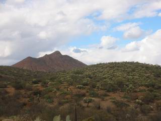
Thick cholla forest, Antelope Peak behind
Sure enough, we dropped to cross a wash and Shane’s rear tire went flat. Little did we know that we’d spend the next hour at this wash. Fortunately we were more or less out of the wind, but the storm clouds finally catapulted out of the Catalinas heading straight for us. He fixed his flat the first time while I patched his tube. We all saddled up, ready to ride. Lee was halfway up the next rise before we hollered at him that the tire was flat again. Now the Indy 500 crew was back at work again, all of us working on his tire/tubes. I recommended the Slime, but for some reason we put in a patched tube again. Saddle up, this time I ride up the next rise only to be called back. What in the name of beelzebub’s trousers? Now things are looking bad. We can’t get his tire to hold air, it’s getting late and the storm clouds are incoming. This time we threw the slime in, and after some frustration, we were off at last.
We rode some nice singletrack, then Shane announced that the slime tube was losing air. I ripped out my pump to air it up, then told Shane to just start riding. He took off in a fury with us in tow. The storm moved in, dropping some rain and gusting wind, but we barely got wet. It blew over us quickly, but we could see more dark clouds trapped on the Catalinas.
Lee and I marveled at the singletrack that just seemed to never end. We kept expecting it to peter out, get overgrown, or AT LEAST become unrideable. But no! Here we are in one of the more remote areas of Arizona, sampling some of the best singletrack in the state. There’s really some big country out there, and we were happy to be enjoying it. Most of all, we were impressed by all the hard work put (recently) into building this trail. Our information on the trail said it did not exist for 3-4 miles of ‘hard to follow’ hangers/cairns/etc. It’s funny how expectation colors experience. Perhaps the strategy is to expect the worst? Maybe not.
We climbed away towards the north shoulder of Antelope Peak, surfing the contours of the landscape, then emerged on a dirt road that took us to Freeman Rd. It was decision time, but first we rolled west to find the continuation of the AZT. It looked enticing, but the time of day forced us to retreat. We thought about Willow Springs Road, but were not sure of the connection, or how rolling it would be. We also knew that it was time to pay the piper–tail wind north means head wind south. It could have been a very difficult ride back.
The other option, of course, was very difficult as well. Dudleyville is down at the San Pedro river, round about 2000 feet. But we would have an easy blast down, some flat suffering on the windy road to Mammoth, then a steady climb back to Oracle (4000 or so feet). We chose studlyville since we had a secret weapon–roadie Shane Peltonen.
We blew over 2000 feet of elevation cruising down Freeman Rd. It was a descent straight out of the Great Divide. After climbing for hours (or days) on the divide we’d blast down to Del Norte or some other town, blowing all our elevation in one glorious descent. Easy coasting, beautiful scenery, eyes scanning distant mountains, the route before us, and adventures unknown.
The San Pedro river, or should I say forest, was a treat. We rolled through thick forests, deep underbrush, crossing the ‘river’ (aka a creek) before emerging in downtown Dudlyville. It was a quiet, stinky Sunday afternoon in Dudleyville (perhaps I can spell it differently each time) when we headed out on AZ highway 77 for Mammoth.
Shane: “Buckle up boys…”
No one ever said he couldn’t take a strong pull on the old pavement. This pull lasted about 13 miles into a stiff wind, and Lee and I could barely hold his wheel. 22 mph on a mountain bike, slightly uphill, and into a head wind? You’ve got to be kidding me (and if I were reading this, I wouldn’t believe it either).
Nonetheless, soon Shane and I were sprinting for the North Mammoth city limit sign. I tried to get out but with the wind couldn’t get the last wheel length on him before the sign. But it was a double sprint — the real Mammoth city limit sign was just ahead. I got a good kick and was maybe 30 feet ahead, holding on for dear life. He’s got too much speed though. I was 0/2 and my legs were now smoked. At least I didn’t have a big climb ahead….. oh, wait.
I knew a strong climb wasn’t in the cards for me, so Lee and I spun up it, wishing we had just a bit more daylight. We rigged up his light to shine backwards on my pack, which seemed to help, but it was still a dangerous climb. Turning onto Tiger Mind road was a relief. The last, dark, climb back to the truck was a good chance to spin out our legs.
All said it was a solid ride and one worth repeating. Flat protection (slime or tubeless–not liners) is essential and would have saved Shane’s bacon (ours too). Belting down 77, sucking Shane’s wheel, I couldn’t help but wonder what it would have been like to be thru-riding rather than day riding. Lee and I would be down by the Gila enjoying a nice evening, or perhaps stuffing ourselves in Superior, thinking about what lies ahead for us on the trail. It’s such a different world, but, one thing is the same: my thoughts are fixed on what lies ahead:
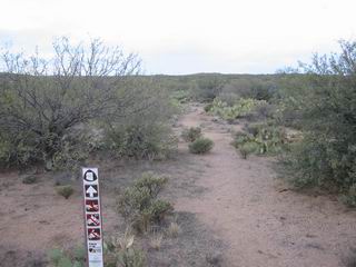
The unknown.. north of Freeman road
67 miles, 8500 feet of climbing, 9.5 hrs (only 7 moving time).

Leave a Reply