Volume 1 (Colorado Springs to Leadville) can be found here:
http://www.topofusion.com/diary/2007/07/30/ctcar-tour-volume-1/.
~—~
Mike, Lee and I left PB (Leadville) early. Pavement is good for one thing: warming up. Good thing, because the Elbert Trail starts out steep and serious.
In my mind there was a 100% chance of afternoon thunderstorms. I figured we would make it into Aspen by mid-afternoon, just late enough to survey the sky and decide to seek shelter. A short day means I’ve got matches to burn.
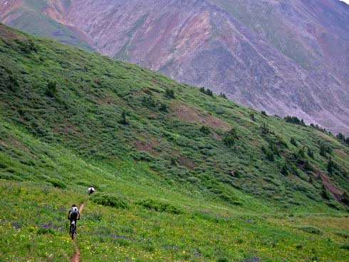
Or so I thought. I weaved through CT backpackers and Elbert peak baggers, tires clinging to the precipitous trail. My heart was pounding in my head, but it felt good. I remember stealing quick glances ahead on the trail and thinking I’d be walking by the time I got “there.” Not so. Pedals kept turning, tires continued to find traction, lines found on ledges. Brilliant.
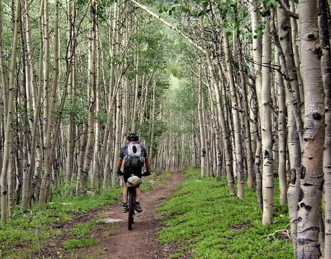
Soon enough we were contouring and blasting through aspens.
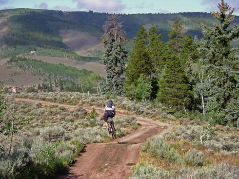
The CT hits a dirt road, but we take a singletrack down to Twin Lakes. Someone has been fooling with what was (in my mind) a nearly perfect piece of trail. Seems like it is going to be adopted as either CT or CDT. Too bad they felt the need to modify it. Still a fab trail, and a wonderful descent.
It was time to wave goodbye to the Colorado Trail as it begins its less-than-desirable traverse along the Arkansas river valley. It’s not bad trail, but we decided to test our fate with a different route, Mike’s route.
First we had to get over the divide. Wilderness forces us on pavement, under the name of Independence Pass. I had never been over the pass, so my interest level was high. I love a good climb, when in the right mood. And going above treeline is always a treat, even on a paved road.
So it was a great climb. Excitement built near the top, dampened only by traffic and tourists (we belong to the latter category). I was pretty anxious to see the other side — new territory for me. The ‘other’ side did not disappoint. I put on every piece of clothing I had for the descent. It felt more like October than July at the top.
5000 feet of elevation is a lot to drop. Too bad it was on pavement, but halfway down the consensus was, “great fun, for a paved road!” The corners are tight, the road narrow, and you can usually go faster than vehicles. It gave me a small glimpse into the world of motorcycle touring. It was fun, but I’ll stick to the dirt.
We rolled into Aspen, where Lee took the reins. He shot off in front of Mike and I, following his nose to the BBQ place. I don’t think there was any way he could have resisted. I was hungry, so it was good to sit down and eat. Even Mike ate a full meal, to the shock of everyone in the restaurant (Mike often insinuates that eating is a sure sign of weakness). If I pull out a Balance Bar, it’s weakness and cowardice. But a full meal? We might as well have turned in for the day right there and then.
But we didn’t. A call to my parents, always quick on the internet response, revealed no thunderstorms building. We hit the City Market (the less said about the denizens of Aspen the better, at this point), and began riding to the top of Aspen Mountain.
Except it wasn’t really riding. 3,200 foot climb in less than 5 miles. Fresh and unloaded? Great, let’s grind it out! Crispy matches (burnt on Elbert Trail and Independence Pass) and loaded bike? You’re walking, my friend.
And so it was. Mike took the lead, pushing his bike at a steady pace. It was sticky and hot, with the absence of cooling wind. But I’ve seen worse ways to gain elevation. Lee and I leap frogged each other for a while, before finally reaching the top of the gondola, whose zipping cars had been mocking us the entire way up the mountain.
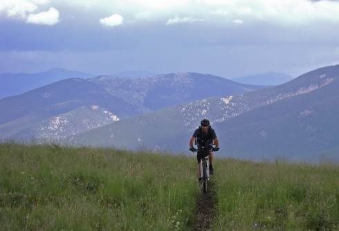
Friendly ski patrol gave us some beta on possible shelters for the night. It was still looking amazingly clear as we set off to traverse Richmond Hill. We didn’t gain much elevation on this heavily used 4wd road, but we sure climbed a lot.
I had no idea what to expect. We were following Mike’s route and ideas now. It was great, really. I’m used to being the driving force behind all route beta and map studying, but instead I just let it unfold.
A few tire tuffy’s passed us as I began to understand the character of the area. It was muddy and ripped up, but I was happy to be spending more trail time up high, rather than attaining a high pass and quickly descending. Mike’s, “we don’t spend enough time in places like this” quote originated here along Richmond Hill.
And he’s right. Lucky for us, we got to spent a nice night up there too. For many reasons, this was a great night, though it did rain. Lee spent some time repairing his rapidly failing titanium rack. It didn’t make it very far, but was still doing the job, for now.
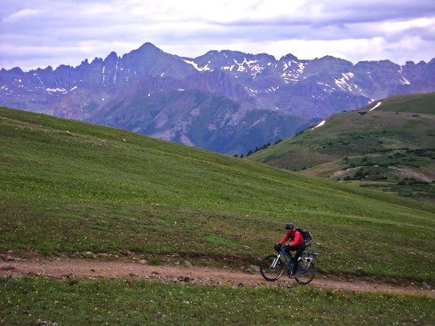
It was pretty special to wake up at 11,500 feet and step out into the early morning alpine air. We followed Richmond Hill, with its fall-line ups and downs, until we dropped into Taylor Pass.
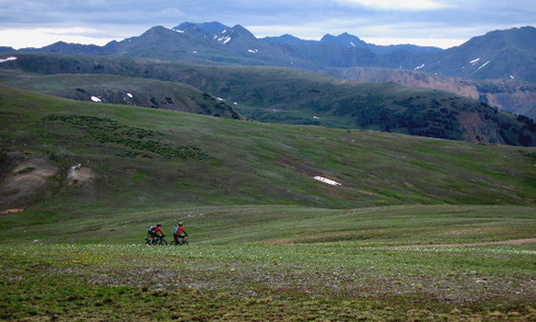
Lee and Scott along Richmond Hill
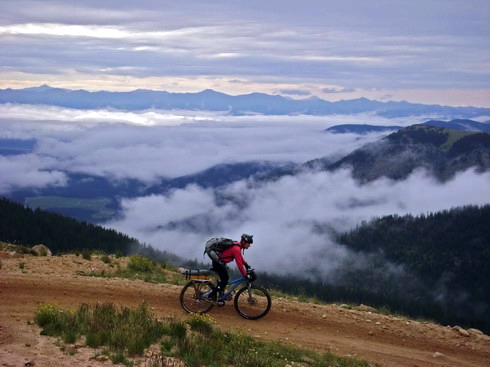
Fog concealed Taylor Park and Reservoir
At Taylor Pass we took more primitive roads and eventually moto trail towards Star Pass (one “R”). The trails were heavily eroded and not all that fun to ride, but the scenery and new-to-me factor made it well worth being there.
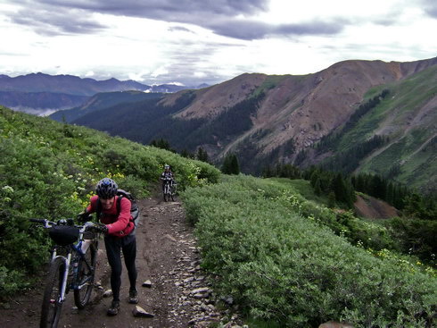
Hike a bike towards Star Pass
Eroded moto-track near Star Pass
Mike cleaned this steep pitch, after which I muttered, “Great, now I have to ride it” to Lee. For whatever reason I just wasn’t feeling it this morning.
At the foot of Star Pass Mike began weighing options. It’s been some time since he rode up here, so he was pretty much shooting from the hip. But the goal was clear – try to find a fun, contouring descent.
First we contoured over to the pass just east of Crystal Peak. This part of the trail was great. There was only one obvious trail at the pass, and I’m not quite sure what happened, but suddenly we were too far down to backtrack, and it was obvious we were fall-line descending. Doh! Mike was pretty distraught, but given the character of everything I’d seen so far, I was skeptic that any other trail in the area could be much better.
It was still a good descent, I thought, just not spectacular. It’s a moto trail.
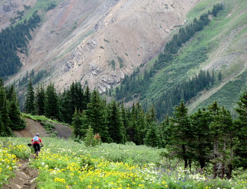
Descending to Cement Creek

Lee descends through the flowers
Mike guessed the switchbacks out of Cement Creek would be too muddy to ride effectively, so he altered the route to head to Flag and Bear Creeks, apparently one of the quintessential rides in Crested Butte. Indeed, at the top of Reno Divide we ran into a group of mountain bikers, including their “support” vehicle. We dropped down the descent.
Crested Butte – home of the most eroded, moto’d out trails in Colorado. Motorcycle use usually doesn’t bother me, but this was over my limit. It’s possible my expectations were too high, but pristine alpine singletrack it was not. I wasn’t feeling the CB love. Left wondering what all the hype is about.
Not bad riding, at all. My wheels were turning, I was getting air in places, and occasionally you could ride 50 feet without splashing or dodging a puddle.
Lee fought with his rack throughout the day, finally abandoning it in the thicket by Spring Creek (fully intending to retrieve it on his way back to Leadville). We climbed to Doctor Park as the clouds built around us. It was a steep one, but I had shaken off the funk of the day and was feeling good.
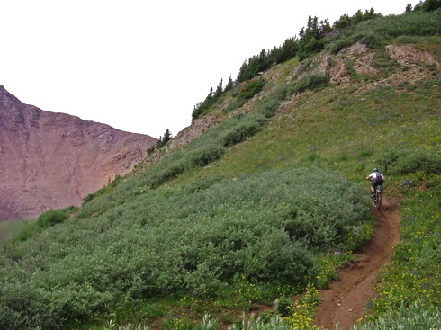
Mike had spoken highly of this trail, having been a part of its rediscovery and re-hab when he lived in CB in the 90’s. Indeed, once we were on singletrack, it was good stuff. Contouring, narrow, technical in places. Most importantly, not destroyed by motos, though their influence was evident.
Lee in Doctor Park, Black Doom hot on his tail
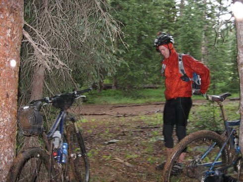
Crossing Doctor Park, the hail assault began. We made haste towards the descent, but we were too late. Water was already flowing down the trail, and blasting us in the face.
After the second thunder crash Mike was gone. I knew we wouldn’t see him until the bottom, where shelter of some kind awaited (we knew there was at least a store in Harmel). Lee and I pulled off into a small grove of trees to suit up in rain gear and wait for cessation of driving rain.
It didn’t take long before we coasted down the slippery trail. Soon mud was packing up thick on my tires, and off trail excursions were necessary. The trail was a river, and I felt anything but “in control.” Rain picked up, making visibility the biggest challenge. I got off to walk a steep/technical spot. I pulled out my allen wrenches to adjust my brakes for more power. I didn’t care if they were rubbing, I just wanted more grab. I waited some minutes for Lee, who was having much more serious brake trouble than I was. I had been a little worried about him to that point, but when I talked to him it was clear he was just walking parts he wasn’t comfortable with, and he was in much better spirits than I.
I was cursing the steepness / nastiness of the trail, the lack of drainage, the sticky mud, and the continuing onslaught of storms. Lee was frustrated with his brakes, but otherwise didn’t think anything was at all the matter. It made me take a step back and wonder what I was so worked up about.
Well, safety is always a concern, and I really wanted to be off the mountain. I wasn’t too worried about the constant lightning, but I have trouble descending with rain in my face. So I took off at the first lull.
As I finished a derogatory thought about the eroded, craptacular nature of Crested Butte trails, the trail crossed a creek and instantly turned sweet.
No ruts, no puddles, outslope (drainage!), mellow grades. Fun, fun, fun and fun.
I flew down the trail, smile growing by the minute. Eventually the trail was dry, though the thunder continued unrequited, behind me. I felt sorry for Mike, who probably didn’t enjoy this section much, riding in thunder fear mode. After a day of somewhat disappointing trails, we were finally on some really good stuff, and he couldn’t really enjoy it (or so I thought).
I sure enjoyed it. I thought about waiting for Lee, but fear of driving rain in my face, and slippery descending, convinced me I wanted to finish the downhill. So I kept rolling. The trail alternated between the “fun fun fun fun” and fun technical stuff. I had plenty of brake power, if no modulation due to sticky cables, so the steep technical stuff was a blast too.
The trail dumped me out into a campground, and as I suspected, there was no Mike. I could see no shelters where I could wait for Lee, so I coasted the 0.25 miles down to Harmel, dragging my wheel in the dirt a few times along the way.
I eyed each overhang of a roof, longingly, then heard Mike calling me from off the road. It took a while before it registered, but he had rented the last room available. Boy was I happy when that realization registered. Lee rolled down a while later, swearing at his brakes, but also glad to see we had a room.
The rest of the night was spent drying out, eating gas station food (the dinner buffet was $30!), and evaluating our bikes. We all worked on our brakes, and came to the conclusion that our bikes needed some bike shop attention. We were ~30 miles from Gunnison, but Mike didn’t think any shops would be open on a Sunday.
Eventually Mike and Lee decided that rather than waiting for a shop to open, they would return to their residences to make repairs and regroup. I didn’t think much of it at the time, but this was the undoing of the trip.
Lee left his overnight gear in Harmel, since he had to pick up his broken rack on the way back to Leadville anyway. After filling the void in my stomach at the breakfast buffet, we continued on the “Gunnison Spur of the Colorado Trail”, destination: Gunnison.
Interesting route, interesting trail. Worth doing, for sure, but I think Dave Wiens described it best (to us): “The whole section is tough…lot’s of agonizing, steep ups and downs.” Emphasis on the agonizing part.
The first few unnecessary elevation losses can be avoided by taking any one of 7 or 8 contouring cattle trails. But once we got far enough up Beaver Creek there were no shortcuts. I had to turn my GPS off elevation display — it was too demoralizing to watch how much hard earned elevation we’d lose on the next super steep descent.
Steep up, steep down
The descents may have been steep and unnecessary, but at least they were sprinkled with jumps. So it wasn’t a total loss.
We crossed Beaver Creek and moved into the mud. Yes, it had rained hard yesterday, and Mike and I found ourselves walking and sliding. Lee kept riding, much to our confusion. True, he had ditched his camping gear. True, he weighs at least 30 pounds less than us. True, he had large tires at low pressure. But still! His bike was barely making a track in the mud where my shoes were packing with mud. I’d turn around and see that my tires were making more of intend than his, even though I was walking and he was riding!?
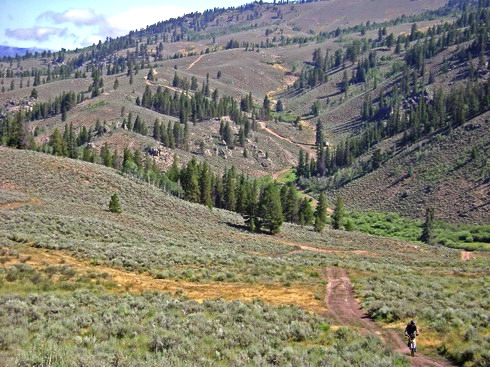
The amazing mud floating Lee Blackwell was waiting for us at the junction with Lost Canyon Road. Mike pulled out Dave Wein’s written description that was to guide us to more singletrack (thus far had all been dirt road and 2 track). I had drawn a best guess GPS track based on the description, but I doubted its accuracy.
My track saved us a seemingly unnecessary climb, and soon enough we were staring at a stunning 360 degree view. Descending along Signal Mesa was a treat, even on the double track. Dave’s directions were right on, and our expectations for the singletrack were thoroughly exceeded. First the trail wound around between the sage, but then it began contouring the hillside, with some great flow.
The old water line took us, without climbing, into the backdoor of McDonald’s, where we sat to discuss the future. I had realized, on the way down, that once we disbanded, that was probably the end of the trip. We’d look at wunderground.com and question the wisdom of venturing off into the San Juans. I was feeling good, and my bike was in good working order (just needed some new brake cables), but I must admit that the constant rain (especially at night) was getting old. So I wasn’t too bummed about it.
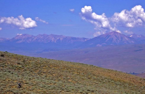
I debated about staying in Gunnison while Mike and Lee went home for repairs and a new rack. But in the end I took the ride back with Lee’s brother in law to Leadville. At least that way I’d be closer to home. We drove over Cottonwood Pass, where I got to survey much of the terrain we had just crossed, not to mention dream of other rides in the area.
Matt Lee rode right in front of us as we came down off Cottonwood Pass. We stopped and chatted a bit about his “tour” paced CTR ride.
As predicted, the weather didn’t look too inviting, and a violent storm in Grand Junction closed the door in Mike’s mind. This phase of the trip was over. Here’s hoping phase two gets off the ground. The current thinking is to restart in Leadville, trying a still different route in the Aspen/CB area.
Trip stats:
370 miles
52,000 feet of climbing
7.6 mph average speed (shockingly high)

“If I pull out a Balance Bar, it’s weakness and cowardice. But a full meal?”
Yeah, so then what does ice cream signify?
Good stuff Scott. I need to retire or take a leave or something, there’s so much to explore. I’ve been up and over Star Pass and through Doctors Park. Too bad you hit DP in a heavy rainstorm, it really is a fun, fun trail.
Later –
Ed