I’ve ridden with the Dakota 20 quite extensively over the last couple months — about 1000 offroad miles according to the odometer on the unit. My conclusion is that it is a solid GPS for cycling and bikepacking.
Screen Readability
The biggest reservation cyclists have with the touchscreen Garmin units is that of screen visibility when used on the handlebars. The Dakota 20 is an improvement over the Oregon 300t I previously owned, and is good enough for most situations. With certain angles of bright light the screen is hard to read, but the difficulty is not enough for me to give up on the unit, like I did with the Oregon 300t. The only situation I would not use the Dakota for is racing — when quick confirmation of the route ahead is critical. For normal exploratory rides and everyday shredding, it works fine.
Edit in 2011 – I have found that using polarized sunglasses makes a HUGE difference in the readability of the screen in the sun. I am now regularly using this GPS on the handlebars.
Use in hand
In the hand, the GPS is fun to use. It came in quite handy when I spent a week doing trail layout in a remote location. Having USGS 24k quad maps with my current location on them, was very useful in planning ahead and for quick orientation. When the unit is held in the hand it is easy to orient it for maximum visibility, so that issue is really only annoying when the GPS is fixed to something (e.g. handlebars).
Accuracy
In the accuracy department, I think the Dakota is a small step above older generation units. It is very quick to find its location, and in taking daily waypoints at a surveyed brass cap, the Dakota did better than my crewmate’s 60CSx. Tracklogs come out well, as expected. I have only noticed the expected number of anomolies here and there.
Battery Life
Battery life is shorter than a 60CSx or VistaCx, but still quite acceptable. I tend to get ~15 hours with years old rechargeable batteries.
Things I like:
1) Small and light unit, big screen. Similar in size to the VistaHCx, but larger screen.
2) Faster CPU – menus and maps respond and draw much faster than older units.
3) The custom maps – this feature is huge, never before seen on a Garmin GPS. As soon as I heard about it, I worked hard to add full support to TopoFusion. More about this in its own section below.
4) Track manager – no need to split tracks into 500 point chunks anymore. Just keep the track under 10,000 points each and you can quickly get it onto the unit. Much easier! You can also store quite a few 10,000 point tracks, and easily turn them on/of, look at profiles, etc.
5) HR / Cadence – I have a Garmin HR strap from an older Forerunner GPS, and the Dakota picks it up and stores heart rate data in the GPX, which is then read by TF.
6) Triaxial compass – I rarely use the compass when riding, but for trail layout it was nice to not have to hold the GPS level to get a solid reading.
Things I don’t like:
1) There’s no setting to change the color of the active tracklog. It’s always black and sometimes hard to see.
Edit in 2011 – you can change this now.
2) You can only have 100 custom map tiles. This amounts to about 580 square miles using the Topo 4m tileset (USGS 24k maps). Good enough for most epic rides, but not for a multi-day bikepacking trip.
3) No ability to turn on/off different custom maps. You can have overlapping maps, and the draw order can be controlled in TopoFusion, but it would be nice to have both topos and aerials for an area and be able to choose between the two.
4) The touchscreen is neat to use when you’re not riding, but I’d prefer tactile feedback when the wheels are spinning. Sometimes you hit a button and don’t know if you really got it.
5) Track archiving is a little strange. The unit saves out a new GPX file every 10,000 points (roughly). I think the way the Vista or 60CSx does it (archiving one track per day and naming it by the date) makes a lot more sense and is easier to deal with.
Edit in 2011 – there are some new options for this as well.
Note: hopefully the first three will be corrected by firmware updates in the future. Maybe the 5th as well.
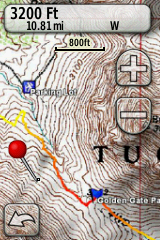
Tips for using Custom Maps on the Dakota/Oregon/Colorado units:
2) With your GPS plugged into your computer, create a directory called “CustomMaps” in the “Garmin” sub directory on either your GPS itself, or the SD card. Map images in the .KMZ (google earth tile) placed in either CustomMaps directory will be automatically loaded by the GPS.
3) Use TopoFusion — it has the ability create large scale KMZ files from any of the available imagery in the software. That includes 24k topos and high res color aerials for most of the country. You can also add your own custom maps to TopoFusion and upload those. Just use the “File->Export View” command to get started.
4) Use the custom maps feature to upload tracks, too. Anything that is displayed in TopoFusion gets rendered and put into the custom map. That means you can have hundreds of GPX tracks loaded and they will all show up on the GPS. No more simplifying and splitting of tracks, worrying about whether it’ll all fit or not.
I have found this to be extremely useful. I can load up (or draw) several tracks in an area, change their colors/widths, and then get them all very easily onto my GPS, laid over a highly detailed basemap.
This is hands down the best way to get a GPS network onto a GPS for use in the field.
5) Use Topo 4M. I’ve found that the white background on Topo 4M makes the map more readable than the Garmin vector basemap (e.g. Topo 2008 DVD).
In addition I recommend 4M to cover more area (than Topo 2M) and also so that tracks you have loaded end up thicker and easier to see. You may want to add additional thickness to your tracks by right clicking on them in the map and choosing “Track Properties.”
6) Aerial photographs are cool, but harder to see. I definitely get a kick out of passing a big building and seeing what it looks like from the top, but aerials tend to be a little dark and tough to read outside on the Dakota and Oregon screens.
7) Remember that you can only have 100 map tiles on your GPS at a time. TF will give you a warning message if you generate a single KMZ file with more than 100 tiles (the number is displayed as you zoom in and out and choose a tileset as well). But even across multiple KMZ files you can only have 100 tiles total. So, be careful.
8 ) You can use Google Earth to preview the generated KMZ file and see what you have. It will look less pixelated on the GPS since Google Earth resamples the map tiles and loses some quality. Still useful to verify what you have.

[…] BikeRadar.com GPSfix Diary of Scott Morris […]
Sounds like you have great experience with the Dak 20
I have had mine for 1 month Has been working well Lots to learn tho
Now I went to torn on faint screen and then goes dead Have tried 3 new sets of AA batts nothing
Any idea? Is Garmin Int..really swamped for customer support I have tried emails and phone 2 days ago nothing?
New item I maybe should have know to get bugs worked out first?
Thanks
Scott
Thanks for taking the time to educate others based on your past experience with GPS devices.
I like road cycling myself, and I would like to get a GPS device, in order to put an end to losing my faster teammates at different events.
What is your take on the GPS technology incorporated in cell phones? I would rather hit two birds with one stone if the 10$ monthly AT&T/GPS fee would be waived.
Are you familiar with the HTC Tilt 2 for AT&T?
Cordially
Robert
Dave — Garmin has a good reputation for customer support. They’ve always helped me out. Keep trying.
Robert — Unfortunately I have limited experience with GPS+phone technology. In general my feeling is that in combining devices you often sacrifice some of the functionality a dedicated device gives you.
Garmin did finally get to me …4 days later It was a corupt file had to remove al files and do a reboot
Works great now Hope it continues Like the unit
Scott, this post has inspired me to finally go buy a GPS and the Dakota looks like a good fit. One question, do I have to buy Garmins Topo to make this thing work off-road.
Thanks for the help! I enjoy your blog immensely.
You don’t need the Garmin topos, no. They are a pretty comprehensive basemap to have on the GPS, but you could use custom maps, or there are a number of free alternatives for vector basemaps, depending on what state(s) you are looking for. See this thread: http://www.topofusion.com/forum/index.php?topic=3796.0
[…] Fanning. I’ve never owned a handheld GPS before, and after exhaustive research and reading Scott Morris’ recommendation, I decided on the Dakota, and I have been most pleased. It’s a cinch to operate, perfect for […]
Scott,
I am planning on doing the APC 116 this coming weekend and was going to use my Garmin Edge 305 for navigating to the GPX that you cleaned up. What I have done in the past for rides beyond the battery life is to bring one of those small AA USB recharger packs and plug it in when the batteries are low. My concern on the APC is I have never ridden these trails and if I lose my GPS nav ability then I will be reduced to map/compass. What are your comments on continuing to use the Edge 305 versus upgrading to the Dakota 20?
Thanks,
Kevin
Kevin–
I don’t have much experience using AA USB chargers and the edge units. However, I do know of some failures — e.g. Dave Harris on the Colorado Trail Race this year. I prefer something that directly uses AA batteries.
Whether or not it’s worth upgrading for the APC, I don’t know. You could turn the GPS off for significant portions (like the whole neutral portion — you might be able to get away with it.
If you are planning on doing other 12+ hour rides (or bikepacking), I’d say upgrade for sure!
Thanks for the feedback. There are two versions available one of which comes with the TOPO U.S. 100K mapping DVD for an extra $50. Is it worth the extra money? I already have the 7.5′ TOPO state maps for CA and AZ so I should be able to use these correct? I’m assuming that I would have to specify what areas to download to the device since the take up so much memory.
Kevin — your existing maps wouldn’t load onto the unit. Not without a bunch of trouble. Using TopoFusion you could upload a fair area of topo maps (for anywhere in the US), but they are different than the (vector) Mapsource TOPO U.S. DVD. Those basemaps are still somewhat useful, depending on your use. However, there are also some free options for vector basemaps, see this thread for more info: http://www.topofusion.com/forum/index.php?topic=3796.0
Hello Scott,
First thanks a lot for your amazing review. I’m considering to buy the Dakota 20 GPS. I have a few questions though:
Will I be able to store whole Great divide route GPS data (as provided by Adventure Cycling Association) on it? I basically want to use it for navigation (Not super important… I did the Great Divide twice between Banff and Salida so I know the part pretty well. Navigation would be only helpful past Marshall pass to the US/Mex border.) But more important for me is the ability to save and download all the route tracking gps info after I return back home. Will the Dakota 20 able to hold all the data??? I don’t want to carry a netbook and off-load the gps tracks daily???
Scott – great review. You mention you wouldn’t use the Dakota for racing as the screen isn’t perfect – what would be your suggestion for a better racing GPS?
Ian
RichNYC — you’ll have no problem storing the entire divide route. Even a single 10,000 point track is enough for navigating divide, in my experience (I have toured the route and raced it). I wouldn’t bother with the custom maps feature for the divide, though, just stick with an uploaded screen.
As for storing your ride, with 850 mb internal memory you could record the whole thing no problem. The unit automatically archives your data ever 10,000 points. You’d just have to merge it all together after the ride.
IanC — my first choice would be a VistaHCx (or LegendHCx). Small screen, but easy to read, lasts for ~50 hours on two lithium AA’s. No custom maps, but still works for uploading a (split) 10,000 point track.
Thanks Scott, I just bought the Dakota 20 and your TF software… Quite an upgrade from my Edge 305;) BTW, this is my first mapping GPS. I’m really happy that Dakota accepts my old HR straps, too;) Now, I just have to spent time with this little wonder to learn to use it…
One question re. TF: Would it be possible to custom select the 100 map tiles rather then be limited to whatever is visible in TF? Something like in Garmin Mapsource where you can click on specific maps (tiles) and select them for upload to a GPS… This way I could fit more maps around my planned route??? Just a thought…
As for the Divide, I will most likely just put the ACA track on it and upload the free state topos from GPSFileDepot for the whole route. They are small but have plenty of detail to be used…
Scott – Appreciate the time spent on the review. I am a casual road biker (around 2,500 miles per year). I don’t have a GPS yet, but am considering either the Dakota or the Garmin 605, do you have any opinion on which would be better? I like to make cue sheets with turn by turn directions, even if I am only riding locally – the 605 seems to be better for this replacement of my paper cue sheets, what are you thoughts?
Thanks for the review…I was split between the Edge series and the Dakota 20. After reading through your review, the Dakota 20 became the clearer choice for me, I ordered it yesterday!
Rec’d the Dakota 20 today….great GPS signal reception. I was on the 1st floor of a two story school and it tracked my path through the different wings and hallways! Looking forward to using this on the trails!
Hey,
I bought a brand new Dakota 20. new AA, nothing, only lines across the screen and then went dead. Tried 4 different sets of AA. same shiite. Got another dakot. same thing. Finally my 3rd dakota worked well. no problems so far. Hey, what can I say. Poor product, maybe was build on a monday, guy still had a hangover from the weekend. Garmin was clueless. Great GPS thou, now that it works.
Works OK now after the Re Boot problem
However the main gripe is the screen Very fuzzy hard to read compared to the Garmin older GPS Map 60SCx
Is there anything Garmin can do with the Dal 20 Screen Like the size like the touchscreen but the readability is poor
Last question
Do you know if Garmin can repair the screen on a GPS 12 B/W Great unit back in the days but now the main screen has lines all over it?
Thanks
Dave
Dave,
Yes the Dakota’s screen is definitely harder to read when compared to the crispness of the 60CSx. That is really my only gripe against it, as described in my review. However, it is still quite functional. There’s nothing they can do to improve readability — I just hope their next generation of units has improved this aspect.
I don’t know if they can repair a GPS 12, sorry. Most likely they will just try to get you to upgrade to a newer unit.
Scott
Scott – what mount did you use for your handlebar? Have you liked the mount for the dakota?
I use the standard Garmin one. No issues with it, seems work nicely.
Just a quick note, I added some corrections to the above review — esp. the polarized lens make a big difference in the viability of this GPS. I am quite happy with mine.
What would you use for something like the Tour Divide? This? It looks like it takes a MicroSD card for greater storage. Or maybe a DeLorme PN60W w/ SPOT?
Sure, The dakota would work well for TD. Might recommend the polarized glasses (in general) and for screen visibility. I’m not a fan of the PN60, even though the SPOT functionality is kinda neat.
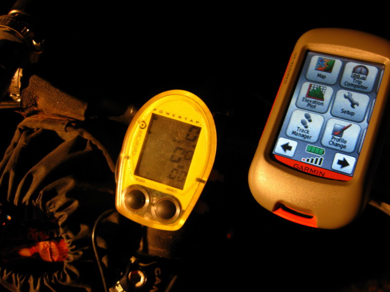
Thanks for the reply. It looks like you’ve got a PowerTap. You’re not tempted by the Edge 800? Maybe your PT is wired…. The 800 looks great on paper, especially paired with an ANT+ power meter, but it sounds like there’s been a lot of teething pain with the 800 and the Dakota 20 has better battery life … but such a small screen! I think I’ve narrowed everything down to the 800 or the Dakota 20 for the TD. Any opinion?
For TD something with AA batteries is the only way to go, IMO. Dakota all the way.
Hmmm … yeah, adding an external AA battery pack to the Edge 800 would be easy but you’re adding weight and complexity to the system (places for water to potentially get in, more stuff to lose or break, etc.).
Dear Sir.
I just recently sold my eTrex Venture HC opting for a better unit. Choosing between the Dakota 20 vs. the GPSMap60CSX.
My priority is ruggedness as I will be using it most of the time in bike trails where I encounter lots of speed bumps. I am also thinking that the Dakota 20 would be better as it is lighter, cleaner, and newer OS. However, I am already good with the old Garmin OS’ which is similar to the eTrex line. The number of buttons is really a good thing for the GPSMap but then its really huge. It’s not nice to carry when navigating in the city e.x. walking in Singapore or Hong Kong.
Here are my usage. Hoping you could help me out.
-Hiking
-Pedestrian Commute in the City
-Biking 90% of the time.
Would the Dakota be fair enough for the job? I fear for the backlight readability, less rugged casing, and the lack of proximity/alarm sounds would dampen the experience. Please enlighten me, I know both are worth upgrading from an old eTrex.
Sincerely.
You say Dakota shows Heart Rate on screen (that’s true) and stores Heart Rate on GPX (that’s not true on firmware 4.7). Could you tell me which version of firmware you tried? Thanks.
@Drey – I would say go with the Dakota over the 60CSx for your uses.
@Gabriel – Upgrade to the latest firmware and you should be good to go. All the recent ones store HR. I have mine set to record tracklog at 1 point / second, in case that has anything to do with it.