
Using PhotoFusion (Old version -- only available in Pro Version now)
PhotoFusion, a feature of TopoFusion, allows you to generate a click-able imagemap of your trips with links to pictures taken with a digital camera. Examples:Tiburon Island
24 Hours of Old Pueblo (2005)
Virgin River Rim Trail
Sutherland/Baby Jesus
CDO+Red Ridge (Snow)
Agua Caliente to Milagrosa
Simply download your GPS track into TopoFusion (or any program that saves GPX format) and point TopoFusion to a directory containing pictures you took during that time. PhotoFusion can do the rest. It will generate both topographical and aerial maps of your trip with small camera icons where you took pictures.
Requirements:
- Digital pictures in JPEG form (.jpg or .jpeg) with EXIF headers containing timestamps.
- GPS Data with timestamps.
Right-click on a GPX file in the listview in the lower right and select "Properties", or alternatively, right click on a track on the map area while in pan mode (hand grabber) and select "File Properties". From the properties dialog box, go to the "Pictures" tab as shown below.
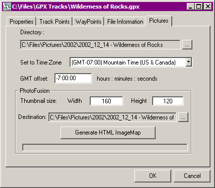
Select the directory containing your digital pictures in the top box by pressing the button to right of it. Then select a time offset associated with your camera (not GPS). For convenience, a drop-down box is provided with common time zone offsets that will fill in the GMT offset box for you. TopoFusion requires this information from you because your GPS data stores the GMT time at each point, not the local time. Your camera is most likely set to local time, so TopoFusion needs to know how far offset it is from GMT. Click OK and take a look at your track. If everything was set up properly, you should see small camera icons on the map located at the places you took the pictures. An example is shown below.
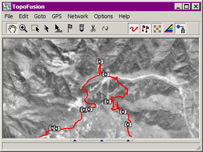
You can right-click on the camera icons to view the corresponding picture.
Error Messages:
- No jpegs found. TopoFusion's search for .jpg/.jpeg files failed in the directory specified, check to make sure you picked the right directory and that it has JPEG files in it.
- No proper EXIF headers in jpegs. TopoFusion found JPEG files, but it didn't find any that had EXIF headers with timestamps.
- No time data found in tracks, can't place pictures! The GPX file you are trying to attach pictures to unfortunately doesn't contain time data. TopoFusion relies on the time data to place the pictures.
- All of the picture times were BEFORE/AFTER the GPS data, adjust the time offset to compensate. When receiving this message, Topofusion will tell you the latest picture time and the earliest trackpoint so that you can get some idea of how you should change your offset. This is most likely caused by an incorrect offset, or a camera with the incorrect time. For the best results, synchronize your camera's time with your GPS's time.