Site is no longer active -- archive only.
Visit http://aztrail.home.blog/ for the current site.
AZT Race GPS Data
GPX removed. See new site.
Old files!
AZT 300 2018 revision 1 data
AZTR 750 2018 revision 1 data
Historic files are in the GPX directory. There are also pre-simplified (10k) versions.
(*) Thanks to John Schilling for developing the Gold Canyon / Jacobs Crosscut route.
See track uploading tutorial for help getting
the GPX file onto your GPS.
AZTR 300/750 cue sheets
Mileage cues - AZTR 300/750 Cues 2018 - rev1
Warning: The cues are were taken using GPS mileage, so expect them to be underestimates, if anything.
Warning 2: The cues are not as detailed when the route is on the AZT.
For detours expect high detail, but otherwise it's up to you to stay on the
Arizona Trail. GPS and maps are highly recommended. See aztrail.org for
detailed info on the trail, maps, current conditions and water sources.
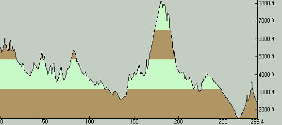
AZT 300 Route Description
The race starts at the AZT Trailhead at Parker Canyon Lake. It follows the
Arizona Trail to the town of Patagonia, passing through Canelo Pass. This ~35
mile section of primarily singletrack will give racers a taste of what's to
come. Expect some hike-a-bike, right off the bat. Elevations range from 4500
to 6000 feet.
In Patagonia, the Arizona Trail heads north into the Mount Wrightson
Wilderness. The race doesn't follow it, but instead state highway 82 to
Sonoita, regaining the Arizona Trail as it comes out of the Wilderness area
in Gardner Canyon -- just in time for the oh-so-sweet Flume Trail.
The route follows the AZ Trail through Kentucky Camp and onto the newly constructed
Las Colinas and Cienega passages of the trail. The final touches on these segments
were finished just in time for the 2011 edition of the race.
The race then hits pavement on Old Spanish Trail to detour around
Saguaro National Park (wilderness). It passes through the east side
of Tucson, where grocery stores, restaurants and even bike shops
provide opportunity to refuel and repair. Tucson is the halfway point
on the route, at roughly 120 miles.
Out of Tucson, the race climbs the dirt Redington Road to the "side
door", then on connecting 4x4 roads to the AZT coming out of the
Rincon Mountains. Follow beautiful high desert singletrack on the Bellota and
Molino trails, crossing the Catalina Highway and continuing to climb
to Prison Camp.
At Prison Camp, the route begins a 3000 foot paved climb to Summerhaven. At
Summerhaven follow the Oracle Ridge Trail (hike-a-bike shoes on standby),
Cody Trail, followed by more AZT through Oracle State Park to Highway 77.
After a brief stint on Tiger Mine Rd, the Antelope Peak section of the AZT
begins. After countless up and downhill switchbacks, the AZT climbs the crest
the Black Hills, before dropping down to cross the sandy Bloodsucker Wash.
More singletrack begins around the shoulder of Antelope Peak. This is a very
remote stretch of Sonoran desert.
The AZT continues through the Boulders segment. Stunning desert scenery and
quality switchbacks are the hallmarks of these trails. After the Boulders
segment ends, the race continues onto the famous Ripsey ridgeline, where the
views are huge and the climbing is painful. The route crosses the Gila River
on a car bridge in Kelvin, AZ, then (as of 2012) starts a long and newly
constructed singletrack section known as the "Gila Canyons". Gila Canyons
traverses one of the most beautiful and colorful areas in the state, full of
rhyolite formations and saguaro studded ridges. Gila Canyons connects to the
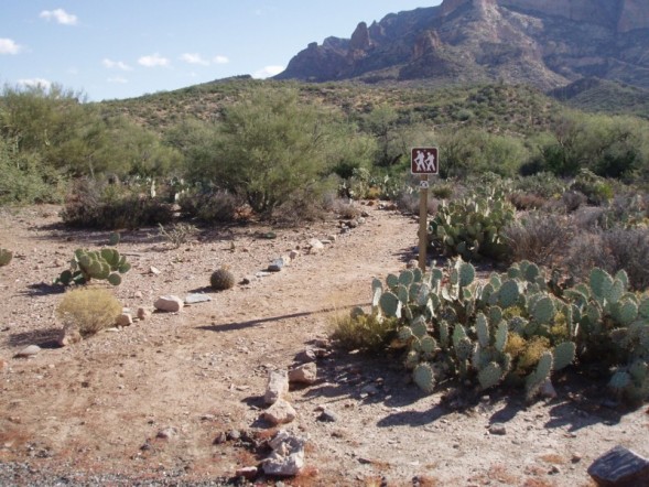
Picketpost segment, the traditional finish of the 300. The finish line is the
hiker sign pictured below, at the Picketpost Trailhead.
Superior, AZ is 4 miles east on US 60. Food, motel, etc can be found
there.