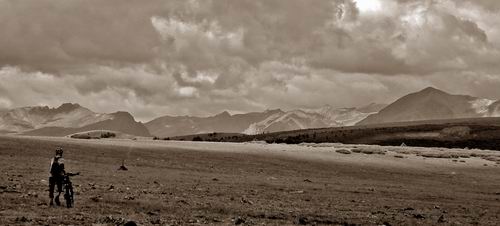
I had intended to restart in Salida. But I got overwhelmed the day before, so I met Mike @ Highway 114, where he dropped out about two weeks ago.
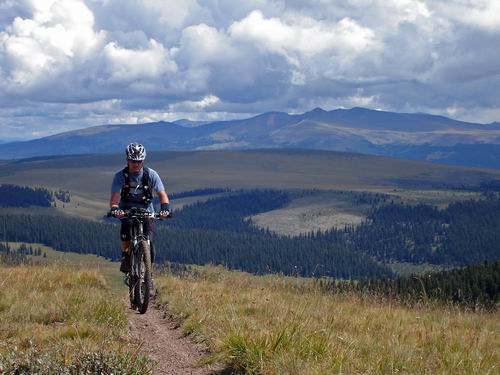
The trail was enjoyably smooth and mellow. Rick climbed with us for an hour or so on his singlespeed.
Forgotten doubletracks, gentle meadows led to narrow trail paralleling Cochetopa Creek. We threw our bikes on our backs to hike for a while. The hike was a pleasant break for my ever weakening legs. I don’t think Mike enjoyed it as much with his single strap system.
We climbed to Los Pinos pass and enjoyed hints of fall color and big views as the sun set. I had a foolishly optimistic outlook on the weather for this trip — how could it be worse than CT Part 1, right? Not possible!
Even when we saw flashes nearby as we camped I looked forward to a decent night’s sleep at hideout campground, complete with gurgling stream to lull us to unconsiousness. How could it be worse than night one of CT part 1?
I wasn’t in my bag 2 minutes before the rain came. No worry, I have my bivy and it worked well last time. I enjoyed the sound of the light rain. Too much — I dozed off… waking to a large puddle in my bivy bag. I brushed as much as I could out and racked my brain trying to figure out how the water was getting in. The rain picked up. Eventually my sleeping bag and clothes became soaked.
It wasn’t comfortable, and I shivered a few times, but the worst part of the night was the fear. I was unreasonably afraid of being cold, or waking up cold, or not being able to warm up once we got moving. When day broke, it turned out to be no big deal at all. But the worry and fear kept me up all night, perhaps more than the cold or discomfort of being wet.
We rejoined the Colorado Trail at Spring Creek Pass in the morning. The first mile was mostly a walk due to caking mud. It wasn’t looking good. Dark clouds were building early, but the threat was minimal for the moment.
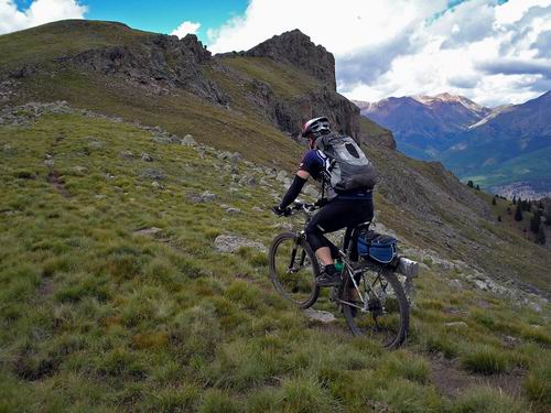
Progress was slow as we climbed towards 13,000 feet. We stood at the base of the final switchbacks to 13,000+. A quick glance at the GPS revealed that we’d be above 13k, on a ridge, on the continental divide for quite some time. A look around the corner releaved incoming rain.
Mike went to look off the side of the ridge.
“Scott, I think I’m going down here.”
I looked off the edge and immediately thought “I’d rather take my chances with lightning than risk one of us getting hurt bush-whacking down that.” But I couldn’t even consider the options before Mike picked up his bike and was off down the scree slope.
I wasn’t going to let him go down alone. Five minutes down I was regretting it. I got trapped on a small rock outcropping. Even if I tossed my bike off the edge I still wasn’t comfortable down-climbing. I had already taken some chances getting to where I was and the thought of going back up was almost as scary as continuing down. I panicked for a few seconds. I looked around saw no rain, heard no thunder. “What are we doing down here? It’s going to take the rest of the day to get down!”
But it was my choice to follow Mike off the ridge, and I knew going in that he doesn’t screw around with thunderstorms.
There’s only one way out of here, and that’s to get it together, stay focused and get down.
I climbed up, traversed, slid out, dropped my bike, cursed, looked in vain for a safe route. I found one that may just work. Mike had disappeared into the trees. He was either waiting out the storm there, or had continued down, I wasn’t sure which.
It did start to rain as I descended a slick’er than snot drainage, but still no lightning. I started losing it again when I couldn’t find Mike. I thought he had continued down. “What am I doing here, by myself, and there still hasn’t been a single crack of thunder?!”
Not five seconds later…. “flash, BOOM!”
Ahem, I was now happy I wasn’t standing on the continental divide at 13,000 feet. I soon found Mike and we continued down.
We dove off the divide at 12,700 feet. The GPS showed 9300 feet at the dirt road below us. Crap.
My bike got caught on a few thousand trees and bushes on the way down. Mike and I also lost each other, once for a good half hour. I was moving slower and couldn’t keep up. He wanted to get the hell off the mountain, with good reason, so he was moving fast and not checking that I could still see him. Visibility was about 20 feet in the forest.
It caused more frustration. I got far enough down that I wasn’t going to go back up to look for him. I wasn’t worried about getting myself down, but I didn’t want to deal with the situation of getting down and not being able to find him. We really shouldn’t have gotten split up. There was no excuse for it.
After some shouting and general confusion, I ended up making my way down a very steep creek — ususally by walking directly in the water. I had to drop my bike down a few mini-waterfalls. At first opportunity I struggled away from the creek only to find Mike 50 feet in front of me.
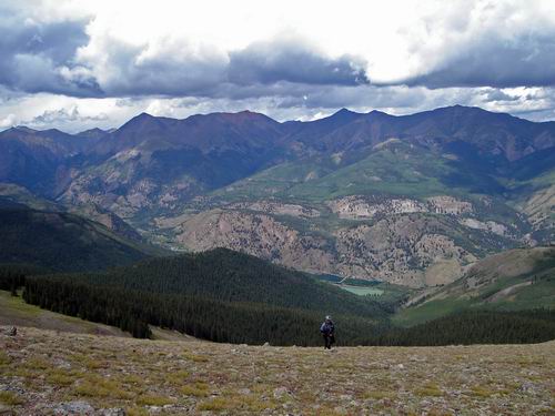
We stuck together as I became more and more tired. My legs were absolutely not ready for this kind of torture. It took us roughly five hours to reach the bottom. We had dropped 3400 feet and only traveled about 2 miles. Ouch.
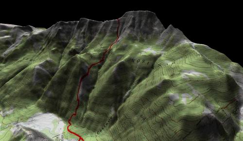
The Drop, rendered in TopoFusion
I was shell shocked, mostly because I hadn’t eaten on the way down. There was a campground and though Mike could have continued on to Silverton (maybe making it there by midnight), we rented a 5th wheel trailer for the night.
The TV had one station, and that station played KyleXY. It was mostly awful, but provided the desired effect — spacing out and forgetting the hardship of the day.
I woke up to rain on the trailer. Then thunder. Lightning at 3am?! Clearly these were no diurnal storms. This front meant business, and we were right in the middle of it.
Cinnamon Pass is above 12,500 feet. Things didn’t look good for crossing it safely. The rain finally let up around 8am so we were quickly out the door. As we began climbing we saw this:
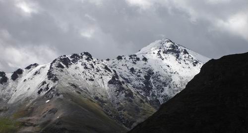
Snow in August. We started to grasp what kind of system we were up against.
We stopped twice to wait out storms from the relative safety of 11,000 foot groves of trees. We were also passed by a new record 50+ tire tuffy’s. Oh yeah, it was epic.
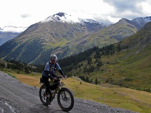
My legs were deathly sore from the hike/bush-whack, but the cycling muscles were rearing to go. I took deep breaths of cold alpine air that felt more like winter than summer. It was a good feeling. We sneaked over the pass just in time. The other side was getting pounded by rain, hail and lightning. We descended quickly.

Radar image from Saturday (day we bailed on the trail)
A young and sporty couple stopped me on my way down. It seemed desperate, but all they wanted to know was how far it was to the top. I told them, heard a bolt of lighting, and then rode off, mid-sentence. If you boneheads want to hang out on top of a hill during the thunderstorm, be my guest, but I’m getting the hell out of here.
Sometimes it’s just plain old fun to get muddy and wet. There was no choice but to blast down the slippery road. Mud flew everywhere. The rain let off and I began to really enjoy the descent. I kind of knew that this was going to be the end of the ride for us. So I enjoyed the last few miles into Silverton as best I could. As long as I didn’t move around on the bike, I felt good. As soon as I stood up or maneuvered, my legs would scream at me.
Mike and I regrouped and considered our options in town. Tourists went about their shopping as we realized we had another day+ of treeline riding and neither of us were willing to repeat yesterday’s debacle. We held little faith that waiting a day or two would accomplish anything. I was further influenced by the soreness in my legs, walking in town, that made me think I was more tired than I was.
So I got comfortable in Silverton while Mike went to ride up Molas Pass. He said the CT was a running stream when he got up there. We went on to Coal Bank pass before getting hailed on. He stuck out his thumb.
The whole state seemed to be going deeper and deeper underwater as we drove back. It confirmed our decision. This storm was widespread and not letting up any time soon. Or so we thought.
Mike dropped me off at my car near North Pass on highway 114. 30 seconds after cresting the pass the fog lifted to reveal clear blue sky. I started wondering. Checking the radar that day confirmed what I feared — not a one thunderstorm. Fie, I say.
So now I’ve got two holes in the CT — Salida to North Pass and Silverton to Durango. Looks like I’m just going to have to restart and ride the whole thing end-to-end. That’ll be a shame, a crying shame.
Despite the thunderstorms, being wet all the time, and associated stress, I still enjoyed my time on the trail. I was glad to not be dealing with it for about 24 hours, then I wished I was back out there again. Knowing that, it probably won’t be long until I am.

despite all the rain it looks like a grand time on the CT. nice to see the diary back up. cheers.
Ok now I know not to do the CO Trail in late summer!
nvnnn
bekar