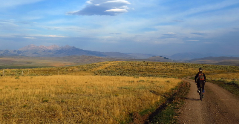
The CDT may have given us a nice welcome to Montana, with well constructed and maintained trail, but it’s still the CDT. We found that out today.
The challenges were many.

It started last night. Soon after inflating her sleeping pad, Ez realized it was quickly going flat. Going to be a long night.
The night was made worse by a persistent chipmunk who thought it his job to harass us. I woke up hearing him chewing on my helmet, then spent the next while trying to listen for more sounds, wondering if I was crazy. Finally Ez heard and saw him and got up. He had already stolen one of her socks. We secured our stuff a little better (all food was already hung up in a tree) and tried to sleep as he kept coming back to mess with our stuff. Eventually he did leave us alone and we got a little sleep. I gave Ez my down coat as extra padding, but it was still a rough night for her.
She took a half a caffeine pill from me in the morning, knowing it was going to be hard to get going. It worked — I trailed behind for the morning and struggled to ride challenging sections.
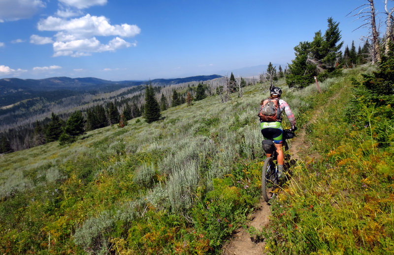
There were many challenging sections. A new trail desinger was at work from Aldous Lake on, and this designer loves steep trail, circuitous routing and fall-line.
A lot of the trail was well made and in good shape, just hard to ride. Or walk.
I made a route blunder early in the day that cost us 30 minutes of pushing through a huge burn area. The Bear Creek GPS data led us astray when we should have stuck with Ley’s map. There’s a shortcut that I saw on the GPS and thought about making up, but the ‘official’ data kept going and the trail looked good. I’d also seen a trail map at the Aldous trail register that had this extra ‘loop’ on it, so I figured it was legit.
Wrong. The trail disappeared. It was clear Bear Creek lost it and never went back to find anything. We found good trail coming from the shortcut below where the GPS data showed it.
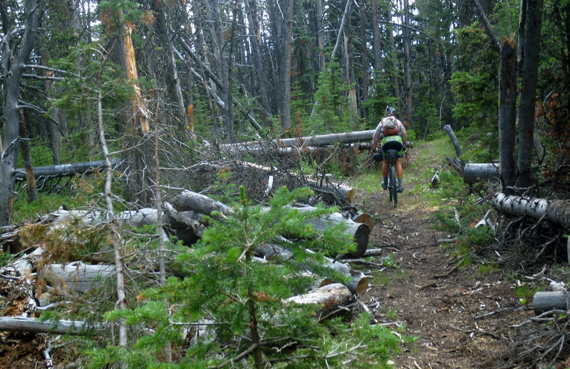
Oh well. I tried not to get frustrated, and it’s true that we’ve still had very few route blunders. The trail itself, even when we got back on it, was difficult enough in the very long burn area.
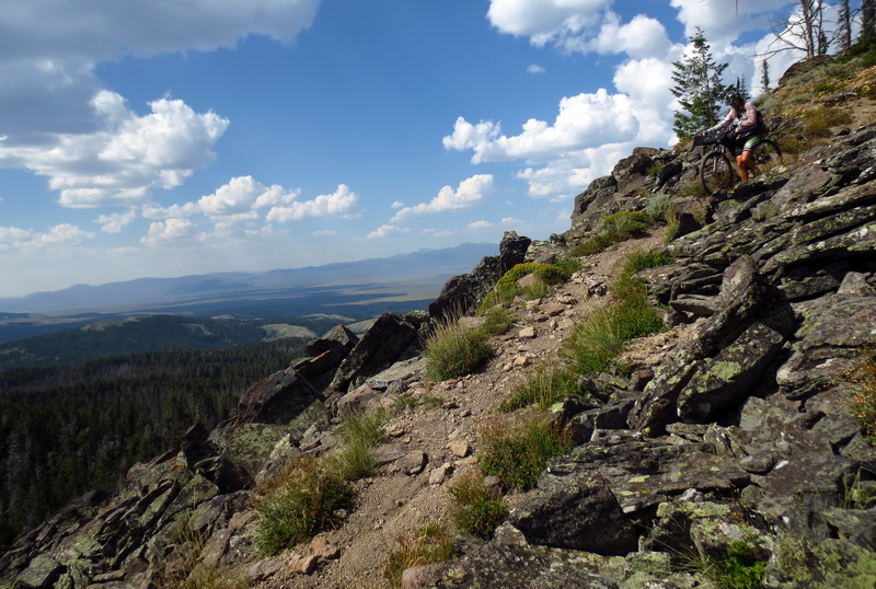
Some fun descending brought us to the base of Big Table Mountain, which was almost entirely a push for us. Stupid steep routing, with a few switchbacks thrown in at the top just for an insult. Pretty cool at the top, with views off the hook and strange twisted forests. Well worth the hike up.

rock spring
The heat of the day had me really looking forward to Rock Spring, which Ley’s map said had good water. It was a let down, with no flow, just stagnant water that featured a dead chipmunk floating in it. Looking ahead on the map didn’t give much hope of new water. It’s dry up here and up on the divide there’s almost nothing to feed creeks or springs.Â
We took 3 bottles of dead chipmunk water just in case, proceeding to East Camas Creek, hoping for water. The Bear Creek waypoint for the creek was totally dry. But one drainage over held the actual creek and there was good water there!

Shattered Ez. She cranked out some impressively steep climbs while under the fog of a terrible night.
seriously? I rode that, but regretted it halfway through
With water we rolled through many miles of new trail. Once again it was in great shape, but poorly routed. Fun descending, bumpy in the meadows and grunt uphills, or hiking. You know, the CDT!
It occurred to me that much of this trail isn’t technical in the usual sense of the word. Yet there’s an incredible amount of skill and attention involved in riding it. You have to be trained at reading the terrain, avoiding branches or sage, feeling for rocks, rubble and branches underfoot. There was no easy riding — you always have to pay a lot of attention and the danger of crashing or grabbing sticks, branches or sage into wheels or derailleurs was always there.
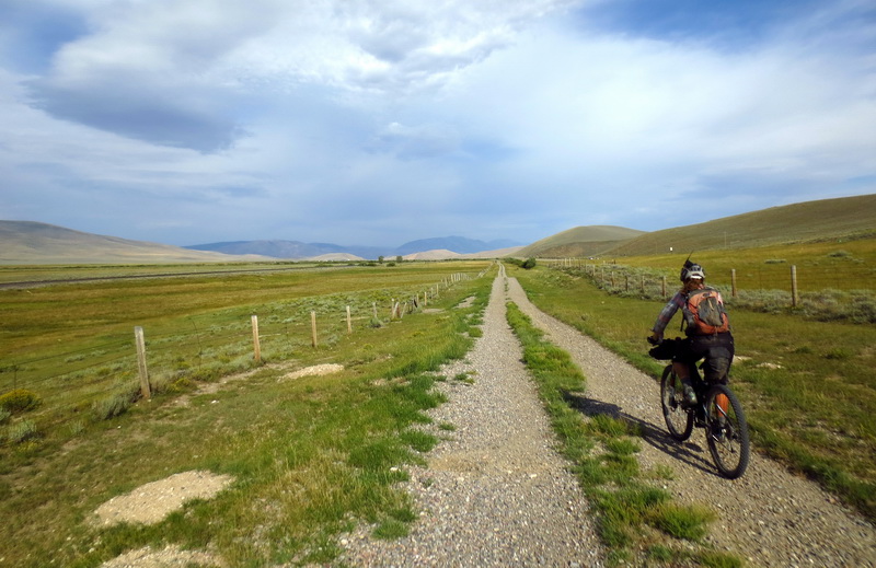
It was such a relief, as it always is, when we finally pushed our bikes up to a trail register and a good surfaced road. I savored the ability to carve turns and make up my line without having to pay deadly attention to what I was doing.
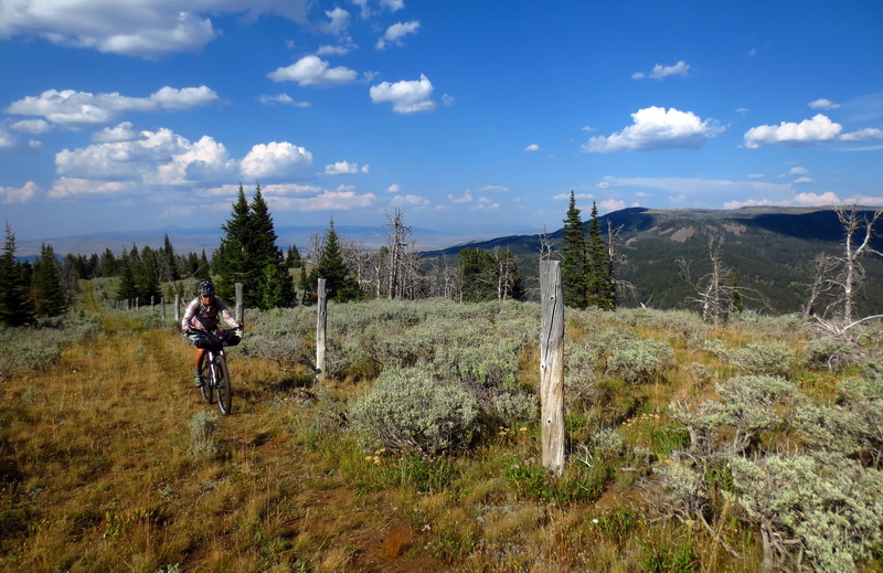
Just before this we had pushed and clawed our way up Little Table Mountain, then followed a delightfully cross country fenceline — the Idaho and Montana Border. Views were awesome. Sage and flowers were everywhere. The evening sun had lost its strength.
We blasted down the dirt road until we found water — a strongly flowing spring just off the road.

Camp is in a nice grove of trees, in theory a short coast from I-15, which we will follow for 20 or so miles into Lima tomorrow. Nearo!
We only covered 26.5 miles today, including off trail excursions. One of the lowest days yet.
Tree count for Corey:
Keg spring to forest boundary – 9
Forest boundary to Aldous – 3
Burn area to base of Big Table- uncountable. Many with new trails around.
Pete Creek Divide to fenceline – 4 or so
Day 81 – Into Lima
It was a beautiful night. No rain, no chipmunks, no nothing. We went to sleep early and got up late — for camp. We had plenty of food.
Neon and Onna walked by as we were getting up. They had camped nearby, also planning to Nearo into Lima.
The trail continued its lovely and hard packed descent, beautiful in the morning light. The Lima Peaks shined across from us, somewhere that we can sadly no longer ride. We caught Neon and Onna before the freeway, coasting along with our brakes, chatting, as they continued walking in. They called the motel in Lima for a ride at the freeway.
We were starting a “recommended Wilderness” detour with Lima on route, so we pedaled the frontage of the freeway for 20 some-odd miles. The frontage varied from lovely 2-track, to paved 2-track (!), to gravel covered washboard, to steep nearly hike-a-bike, to cracked pavement flying with a tail wind. The BS factor was just high enough that we were eyeing the freeway itself for a while, but wasn’t bad enough for us to hop the fence and join the traffic fray. We did have to cross it once when our frontage ended!
We made it to Jan’s while breakfast was still served — the ultimate goal for a Nearo! We shared it with Neon and Onna who had beaten us to town by five minutes. They are also from the Tucson area, and were great fun to talk to.
We have laptops again, and have to figure out the route from here to … Butte, including Wilderness detours. So it’ll be a zero in lovely little Lima. It’s always been a good stop on previous adventures.
Thanks for reading along!

Thanks for all the great posts!
Bear Creek tracks have been accurate on all of the sections we in Salmon have been riding. Those being Bannack Pass to Jahnke Creek and Squaw Mtn to Shultz Saddle.
I cannot speak to the details between Jahnke Creek and Slag-a-melt, but there has been alot of new trail constructed.
You will find some great riding and more “You know, the CDT!”
Good luck and hopefully this Monsoonal stuff will clear out by the time you get to the Beaverheads.
oops, the Starman/Frank Gilliland tracks have been accurate. Can’t speak to the Bear Creek accuracy.
Sorry for the confusion there.